TerraPlus
TerraPlus
TerraPlus helps make data from soil surveys transparent. This web application was created by engineers, to support their own work processes and always keeping usability and speed in mind.
By and for civil engineers
Soil investigation is the foundation for any civil engineering project and is the most important source of information for geotechnical engineers. TerraPlus is a web application that provides a central database for soil investigation data, making it easily accessible and shareable. The application contains all publicly available investigations, but also provides the option to add data.
Central database of soil research
Often, soil investigation data is not available in a central data system, as it sometimes disappears in local project folders or zip files after a person receives the data. TerraPlus frequently collects publicly available data and provides an organization-specific overview. The data is intuitively visualized and structured. This promotes smart data reuse and uniformity in reports.
How TerraPlus works
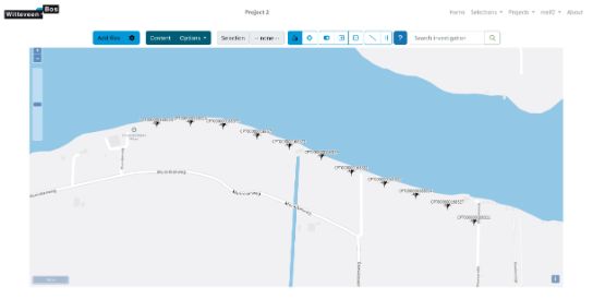
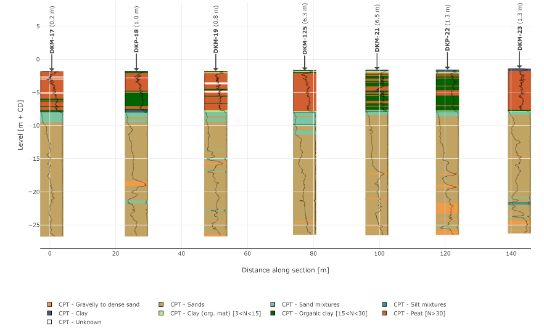
At the core of TerraPlus is a map overview that displays all the investigation points, facilitating fast and seamless searching. It is easy to integrate with common ways of processing and working with soil data. When opening an investigation in TerraPlus, the metadata is displayed together with measurement data. This allows the most important information to be seen at one glance. In addition, the stratification is directly displayed. It also provides multiple classification methods that users can effortlessly switch between. The plot can be adjusted by the user, so that it can be exported directly to a report.
The key features at a glance
- Investigations are transparent: this enables a quick search and reuse of data
- Investigations can be plotted easily and dynamically
- The classification of soil layers can be made according to multiple modern methods
- You can set a minimum layer thickness to filter out small layers
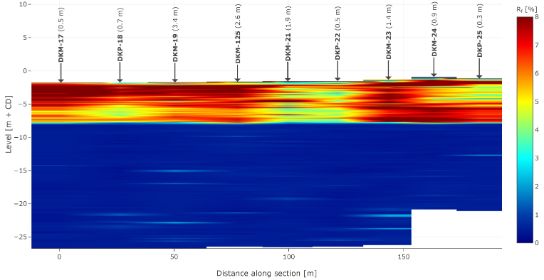
- A geotechnical longitudinal profile is easily assembled from multiple investigations
- You can overlay multiple investigations and make visual comparisons
- TerraPlus can be used as a collaboration platform in projects, even outside your own organization
Interested in TerraPlus? Contact us for a demo.
The TerraPlus team is happy to provide a free demonstration of the web application. Please contact us for more information.
Why TerraPlus?
All data centralised
A central place for all soil data including dynamic visualisations.
Easy dynamic plotting
Probings can be easily plotted, compared and analysed with different methods.
Better collaboration
Collaborate on one platform, with various clients and organisations.

Want to know more?