Towards completion: pedestrian-inclusive design with the Pedestrian Traffic Monitor Rotterdam
Towards completion: pedestrian-inclusive design with the Pedestrian Traffic Monitor Rotterdam
Over the past six months, the municipality of Rotterdam, together with a team from Witteveen+Bos, investigated how the municipality can use 'pedestrian-inclusive design' to combat transport poverty. For this research, three tracks were used to make concrete steps, which were: data analysis with the Pedestrian Traffic Monitor, qualitative research using participation and research of designs of new parks in Rotterdam South. The central question was: how can the current residents of three neighbourhoods in South benefit from new metropolitan developments? We examined the Afrikaanderbuurt, Tarwewijk and Bloemhof neighbourhoods.
Data research walkability
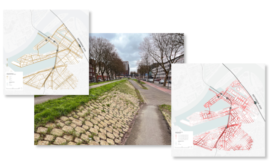
The Pedestrian Traffic Monitor Rotterdam was used to map the current walkability of the research area. LoopAtlas maps were created for this purpose, in which the score on the map for each walkability variable was visualised, such as distance to a park, connectivity, distance to a public transport point, facility density and greenery. The data analysis is an objective representation of the current situation and attractiveness of the area for pedestrians. Many gut feelings of urban planners and mobility experts have been confirmed with this data.
Connecting parks to neighbourhoods
In addition to the data analysis, Witteveen+Bos held interviews with urban designers and mobility experts involved in the Rijnhaven and Nelson Mandela Park designs. In-depth interviews were used to analyse the situation for pedestrians in the research area. Combined with desk research on local pedestrian values, a set of 'social ground rules' was developed that together provided a framework for creating a pedestrian-inclusive design.
Urban designers from Witteveen+Bos used data analysis to discuss the issue of pedestrians. Some of the findings were:
- Neighbourhoods are isolated by barriers, in the form of long busy roads, as well as tram tracks and dykes.
- The fine-grained pedestrian network in the districts offers room for improvement, looking at footpath width, benches and greenery.
- In the neighbourhood itself, there are a limited number of facilities or public transport points, which makes walking around the neighbourhood itself unattractive.
- There are many opportunities to connect important routes from the core of neighbourhoods to the main city axis, and also to design and program these routes as safe and pleasant pedestrian routes.
Connecting expertises for pedestrians
The research was partly funded by Fund for the Creative Industry for the 'Wegen naar Welzijn' programme. The team from Witteveen+Bos and the municipality of Rotterdam that carried out this research noticed that there was a lot of energy to analyse the neighbourhoods in South in the context of broad welfare. The pedestrian made the collaboration truly integral and connected the urban planner, the programme manager, the data scientist and the mobility expert.
Publication this summer
The bookwork with all the results will be published this summer. For more information on this study, please contact Karen van der Spek, Municipality of Rotterdam or Yoline Sprinkhuizen, Witteveen+Bos.
Pedestrian Traffic Monitor

More information?
Wim advises on integrated mobility solutions. The Pedestrian Traffic Monitor helps to map the quality of pedestrian networks.
