Virtually redesigning streets with the InfraShaper

Virtually redesigning streets with the InfraShaper
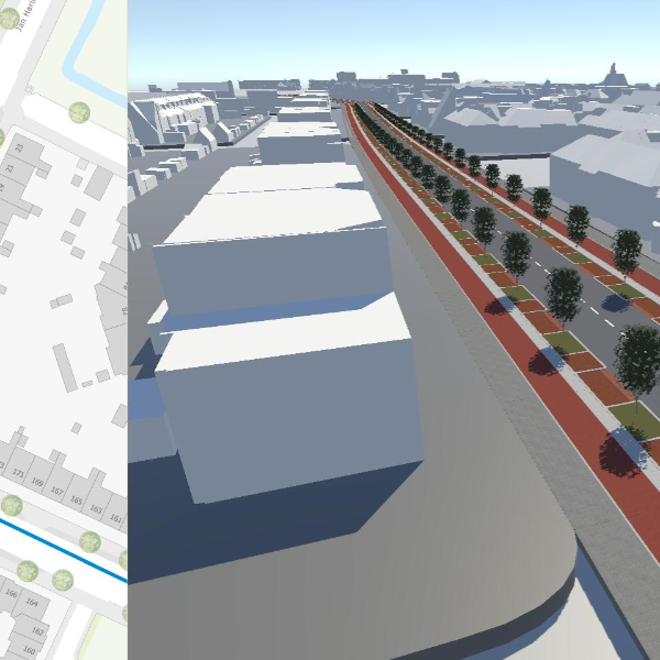
The Witteveen+Bos InfraShaper digital tool generates a 3D environment of an existing area, combined with a Google Maps Streetview Overlay.
When redesigning existing roads, municipalities and provinces often first examine multiple variants of road profiles. This is a time-consuming process. In addition, the road profiles are often taken from handbooks that include the relevant guidelines but there is no link with the existing situation. Witteveen+Bos has now made a web application available for municipalities, provinces and other authorities. After the map and street have been selected, a 3D representation of the existing situation is displayed. In this 3D environment, the various road profiles can be projected onto the existing situation.
Early insight into quantities and costs
This makes it easy to compare multiple road profiles, including the approximate quantities, materials and costs. For example, the required quantities of (red) asphalt, concrete tiles and trees. This can be done at sketch design level, giving a good idea of the quantities and costs at an early stage.
The InfraShaper combines the current streetscape with a Google Maps Streetview Overlay. The advantage of this is that the difference between the current and future situation is visible straight away. This overlay also encourages public participation. The comparison between 'old and new' makes the situation recognisable and more transparent for local residents and other stakeholders.
InfraShaper can be used for all street types
The 3D building blocks of the road profiles can be used for every street if the right design guidelines are available. This includes guidelines such as: in this street, the road profile must start 30 cm from the land registry boundaries, the pavement must be at least 120 cm wide, and so on. Once the road profiles and the rules are known, the models can be used for every street in the target area.