From data to design
From data to design
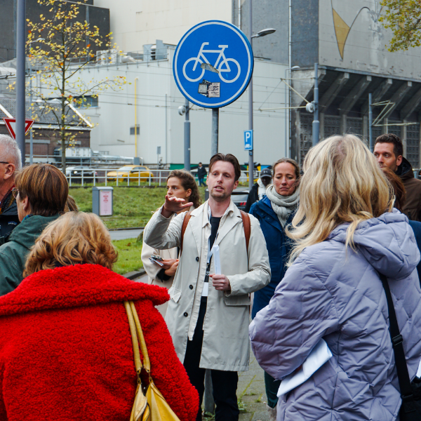
Pedestrians are increasingly being prioritised in urban policy plans, yet we still know relatively little about this group, even though walking is the most accessible mode of transport. So how can you make evidence-based decisions to improve liveability and safety? The first step is to gain a better understanding of how pedestrians move through the city. With the LoopMonitor, we not only provide data-driven insights into pedestrian flows, but we also identify what the city or a neighbourhood needs to become more liveable, safer and more accessible for pedestrians.
Data is just the start
Nowadays, there are various tools available for mapping pedestrian flows. But what does this information mean for urban planning? Where should action be taken, and how do you design routes that people will actually use?
We go beyond analysis: we translate data into ‘pedestrian-friendly’ design principles and spatial solutions that improve residents’ quality of life and mobility.
Benefits of our approach
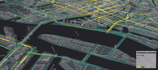
Objective and subjective data for spatial understanding
This approach highlights where pedestrian flows, barriers and connections intersect, and what this means for the spatial quality of an area.
Design principles for connected neighbourhoods
These insights are translated into design principles that help to better connect existing neighbourhoods with new parks, facilities and public transport hubs.
Analysis of feasible options
By combining data, spatial analysis and design expertise, it becomes clear where interventions will have the greatest impact in creating a liveable and accessible city.
Our approach
Strategic change
We begin by working together to define the challenge clearly. In doing so, we look not only at mobility, but at the broader issue of connectivity: which existing neighbourhoods are still not benefiting sufficiently from new developments, and where are there opportunities to link projects and urban planning? Where are there physical barriers for pedestrians, or limited access to public transport, green spaces or amenities?
And what social objectives, such as reducing transport deprivation or enhancing quality of life, does the council wish to achieve? Together, we formulate a clear ambition and define the scale and priority areas. In doing so, we lay the substantive foundation for a targeted and widely supported approach.
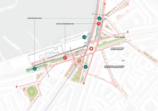
Comprehensive barrier and network analysis
In this phase, we systematically map out the current walking landscape. We analyse the main spatial structure, the detailed neighbourhood networks and the relationship between them. Physical barriers such as busy infrastructure, railway lines, water or differences in elevation are identified, as are bottlenecks in terms of crossability, accessibility and social safety.
We combine spatial analysis, traffic engineering expertise and, where relevant, available data and insights from public engagement. This results in a barrier and connectivity map that highlights where interventions will have the greatest impact on accessibility from a pedestrian perspective and in terms of inclusive design.
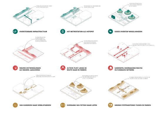
Design for a liveable city
Based on the analysis and strategic vision, we translate the brief into concrete spatial design principles, with the pedestrian as the starting point. Designing for a pedestrian-friendly city or neighbourhood means focusing on crossability, the continuity of walking routes, the quality of the environment, green spaces and social safety.
We develop scenarios in which infrastructure becomes more easily crossable, walking corridors are strengthened and existing neighbourhoods are logically linked to new parks, facilities and public transport hubs. In doing so, we focus explicitly on the human scale and the experience of routes, so that walking is not only possible, but actually attractive.
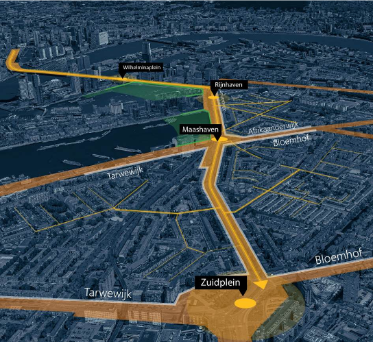
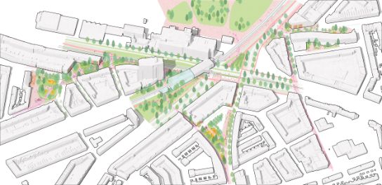
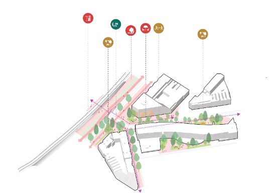
Applying design principles to a network
Having established the design principles, we are applying them to the urban network of Rotterdam South. In doing so, we are investigating how these principles can help improve the walkability of public spaces, making it easier for residents to reach both Nelson Mandela Park and public transport.
By applying the design principles to the context of Rotterdam South, it becomes clear how and where individual interventions can collectively contribute to a stronger and more pleasant pedestrian network. This creates a coherent spatial strategy that demonstrates how pedestrians can be better connected to the city.
Link to ongoing projects and investment opportunities
A key part of our approach is linking the pedestrian agenda to existing plans, programmes and projects. We identify opportunities for integration within area developments, infrastructure upgrades, climate adaptation measures or replacement projects. By integrating the connectivity ambition into these processes, we create a workable strategy and ensure the smart use of budget that aligns with existing plans. In this way, we avoid isolated interventions and build a coherent network step by step.
Quality assurance and implementation strategy
Finally, we provide support in embedding a pedestrian-inclusive approach into policy and implementation. To this end, we first examine how the design principles can be translated into clear assessment criteria. These criteria help local authorities to evaluate future plans and designs from the pedestrian’s perspective.
In addition, we can incorporate these insights into policy frameworks or a phased implementation programme. This clarifies which measures should be prioritised, when they can be implemented, and how they align with existing projects or investment opportunities. If required, we also assist in formulating local monitoring indicators to provide insight into the effects on accessibility and quality of life.
Find out more about how we put our approach into practice
We implemented and tested this approach in collaboration with the City of Rotterdam as part of a study for the ‘Roads and Wellbeing’ project, across three neighbourhoods in Rotterdam South.
Read the report below or download the full study (PDF). Or find out more at: Moving towards completion: Pedestrian-inclusive design with the Rotterdam LoopMonitor
‘During the project, it became clear that the value lies not only in the final report, but also in the process itself.
It’s fantastic to see that the report and the designs are being referred to time and again in follow-up studies.’
Karen van der Spek - Programme Coordinator, Rotterdam Loopt


From Rotterdam South to your area-specific challenge
Wim advises on integrated mobility solutions. The Pedestrian Traffic Monitor helps to map the quality of pedestrian networks.
